State Well Number 6853928 is no longer actively monitored

Well Information **
All data are provisional and subject to revision. The Texas Water Development Board (TWDB) specifically disclaims any and all liability for any claims or damages that may result from providing these data. For additional information, including water level and water quality data, search the TWDB Groundwater Database (GWDB).
| County | Bexar |
| State Well Number | 6853928 |
| Status | Inactive |
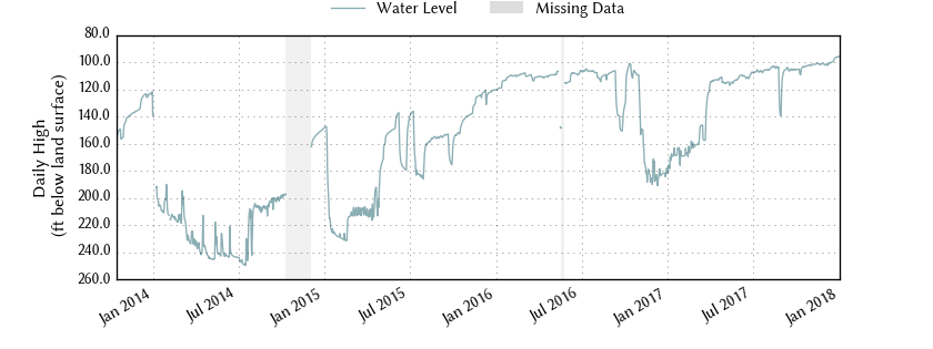
| Period of Record | 2013-10-15 to 2018-01-02 |
| Entity/Cooperator | U.S. Geological Survey |
| Cooperator ID | 290802098232901 |
| Aquifer | Carrizo-Wilcox |
| Formation | Carrizo Sand |
| Aquifer Type | Confined |
| Well Depth (ft below land surface) | 535.00 |
| Instrument | Unknown |
| Transmission | Satellite |
| Groundwater Conservation District | Edwards Aquifer Authority |
| Groundwater Management Area | 13 |
| Estimated Land Elevation (ft above sea level) | 554 |
| Location (lat, long) | (29.1338889, -98.3913889) |
| Download Data | csv json txt |
Data Summary
| Date |
Daily High Water Level (ft below land surface) |
Height Below Most Recent (ft) |
|
|---|---|---|---|
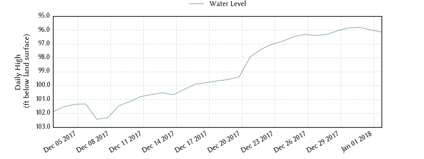
| Most recent | 2018-01-02 | 96.16 | - n.a. - |
| 1 day prior | 2018-01-01 | 96.01 | -0.15 |
| 2 days prior | 2017-12-31 | 95.82 | -0.34 |
| 1 week prior | 2017-12-26 | 96.33 | 0.17 |
| 1 month prior | 2017-12-02 | 102.32 | 6.16 |
| 3 months prior | 2017-10-02 | 105.41 | 9.25 |
| 6 months prior | 2017-07-02 | 108.07 | 11.91 |
| 1 year prior | 2017-01-02 | 176.51 | 80.35 |
| oldest | 2013-10-15 | 167.72 | 71.56 |
Water level data are maintained by the United States Geological Survey (USGS). The data displayed here are provisional values. Provisional data may be inaccurate due to instrument malfunctions or physical changes at the measurement site. Subsequent review based on field inspections and measurements may result in significant revisions to the data. Information concerning the accuracy and appropriate uses of these data or approved versions of the data may be obtained from the USGS.