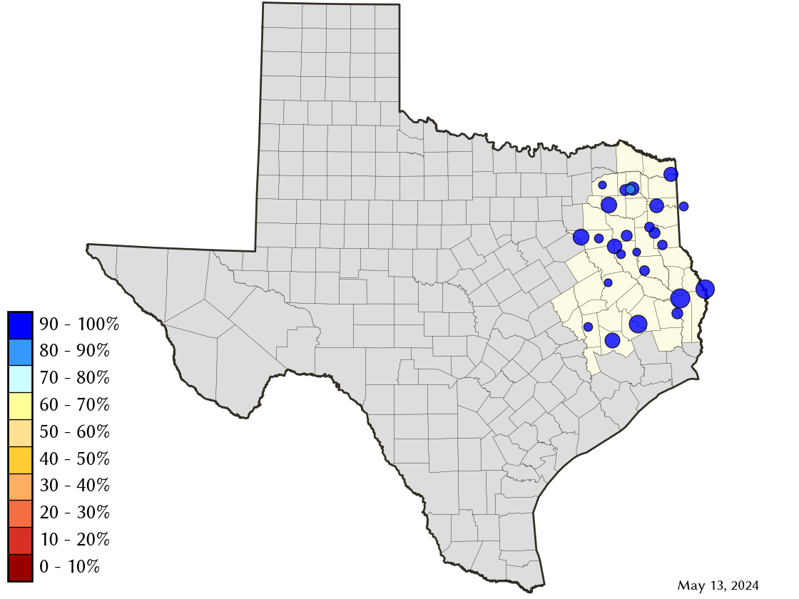
East-Texas Climate Division Reservoirs: Monitored Water Supply Reservoirs are 96.2% full on 2024-04-28
Historical Data
| Date | Percent Full |
Reservoir Storage (acre-ft) |
Conservation Storage (acre-ft) |
Conservation Capacity (acre-ft) |
|
|---|---|---|---|---|---|
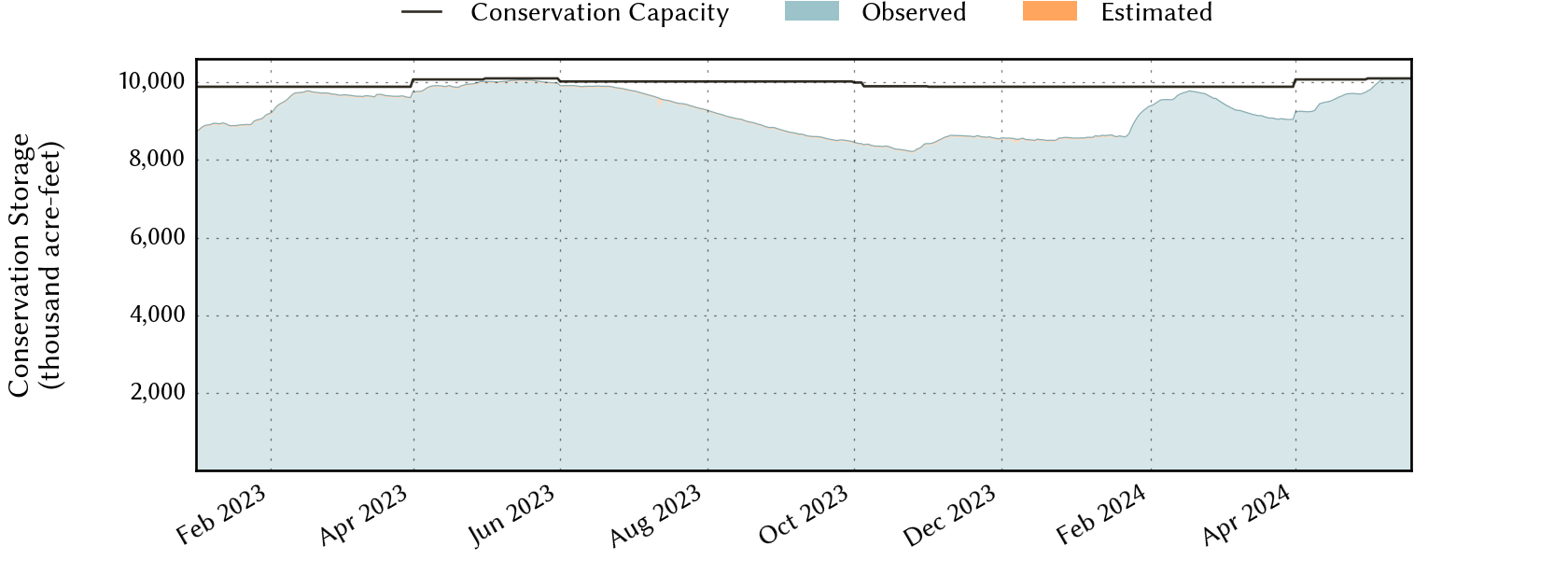
| Today | 2024-04-28 | 96.2 | 12,444,170 | 9,696,610 | 10,074,732 |
| Yesterday | 2024-04-27 | 96.3 | 12,446,023 | 9,702,491 | 10,074,732 |
| 2 days ago | 2024-04-26 | 96.4 | 12,424,664 | 9,707,615 | 10,074,732 |
| 1 week ago | 2024-04-21 | 96.0 | 12,684,259 | 9,672,810 | 10,074,732 |
| 1 month ago | 2024-03-28 | 91.5 | 11,773,532 | 9,050,667 | 9,886,943 |
| 3 months ago | 2024-01-28 | 93.2 | 11,973,521 | 9,218,794 | 9,886,943 |
| 6 months ago | 2023-10-28 | 83.8 | 10,473,691 | 8,299,828 | 9,899,419 |
| 1 year ago | 2023-04-28 | 99.2 | 12,546,728 | 9,993,722 | 10,074,732 |
*
Percent Full is based on Conservation Storage and Conservation Capacity and doesn't account for storage in flood pool.
Area Map
Reservoir Storage
| Reservoir | Percent Full |
Water Level (ft) |
Height Above Conservation Pool (ft) |
Reservoir Storage (acre-ft) |
Conservation Storage (acre-ft) |
Conservation Capacity (acre-ft) |
Surface Area (acres) |
|---|---|---|---|---|---|---|---|
| Athens | 100.0 | 440.58 | 0.58 | 30,637 | 29,503 | 29,503 | - n.a. - |
| B A Steinhagen | 78.4 | 81.43 | -1.57 | 54,326 | 54,253 | 69,186 | 8,790 |
| Bob Sandlin | 100.0 | 338.15 | 0.65 | 208,967 | 192,417 | 192,417 | - n.a. - |
| Caddo 1 | 100.0 | 170.26 | 1.76 | 177,440 | 29,898 | 29,898 | 30,610 |
| Cedar Creek | 100.0 | 322.64 | 0.64 | 665,957 | 644,686 | 644,686 | - n.a. - |
| Cherokee | 100.0 | 280.37 | 0.37 | 46,308 | 40,094 | 40,094 | - n.a. - |
| Conroe | 100.0 | 201.02 | 0.02 | 418,539 | 417,577 | 417,577 | 20,433 |
| Cypress Springs | 100.0 | 380.73 | 2.73 | 75,858 | 66,756 | 66,756 | - n.a. - |
| Fork | 100.0 | 403.64 | 0.64 | 653,679 | 605,061 | 605,061 | - n.a. - |
| Gibbons Creek | 99.7 | 246.97 | -0.03 | 27,349 | 25,645 | 25,721 | 2,550 |
| Houston County | 100.0 | 260.17 | 0.17 | 17,885 | 17,113 | 17,113 | - n.a. - |
| Jacksonville | 100.0 | 422.16 | 0.16 | 25,918 | 25,670 | 25,670 | - n.a. - |
| Lake O' the Pines | 100.0 | 233.82 | 5.32 | 344,652 | 241,363 | 241,363 | - n.a. - |
| Livingston | 99.9 | 130.97 | -0.03 | 1,601,174 | 1,601,174 | 1,603,504 | 77,608 |
| Martin | 100.0 | 306.13 | 0.13 | 76,372 | 75,726 | 75,726 | - n.a. - |
| Monticello | 92.6 | 338.71 | -1.29 | 32,181 | 32,181 | 34,740 | 1,884 |
| Murvaul | 100.0 | 265.48 | 0.18 | 38,904 | 38,285 | 38,285 | - n.a. - |
| Nacogdoches | 99.1 | 278.83 | -0.17 | 39,153 | 39,151 | 39,522 | 2,169 |
| Palestine | 100.0 | 345.89 | 0.89 | 388,237 | 367,303 | 367,303 | - n.a. - |
| Sam Rayburn | 87.5 | 161.12 | -3.28 | 2,519,743 | 2,500,787 | 2,857,077 | 104,327 |
| Striker | 97.6 | 292.79 | -0.21 | 21,391 | 16,469 | 16,878 | 1,938 |
| Sulphur Springs | 99.8 | 458.93 | -0.02 | 17,710 | 17,710 | 17,747 | - n.a. - |
| Toledo Bend 2 | 100.0 | 171.90 | -0.10 | 4,474,766 | 2,235,333 | 2,236,450 | 182,009 |
| Tyler | 100.0 | 375.63 | 0.25 | 78,470 | 72,073 | 72,073 | - n.a. - |
| Wright Patman | 100.0 | 230.18 | 2.68 | 408,554 | 310,382 | 310,382 | - n.a. - |
footnotes
1
Caddo Lake straddles the border of Texas and Louisiana, Texas has rights to 50% of Lake Caddo's total conservation capacity. Percent full, conservation storage and conservation capacity are based on the Texas share.
2
Toledo Bend Reservoir straddles the border of Texas and Louisiana, Texas has rights to 50% of Toledo Bend Reservoir's total conservation capacity. Percent full, conservation storage and conservation capacity are based on the Texas share.