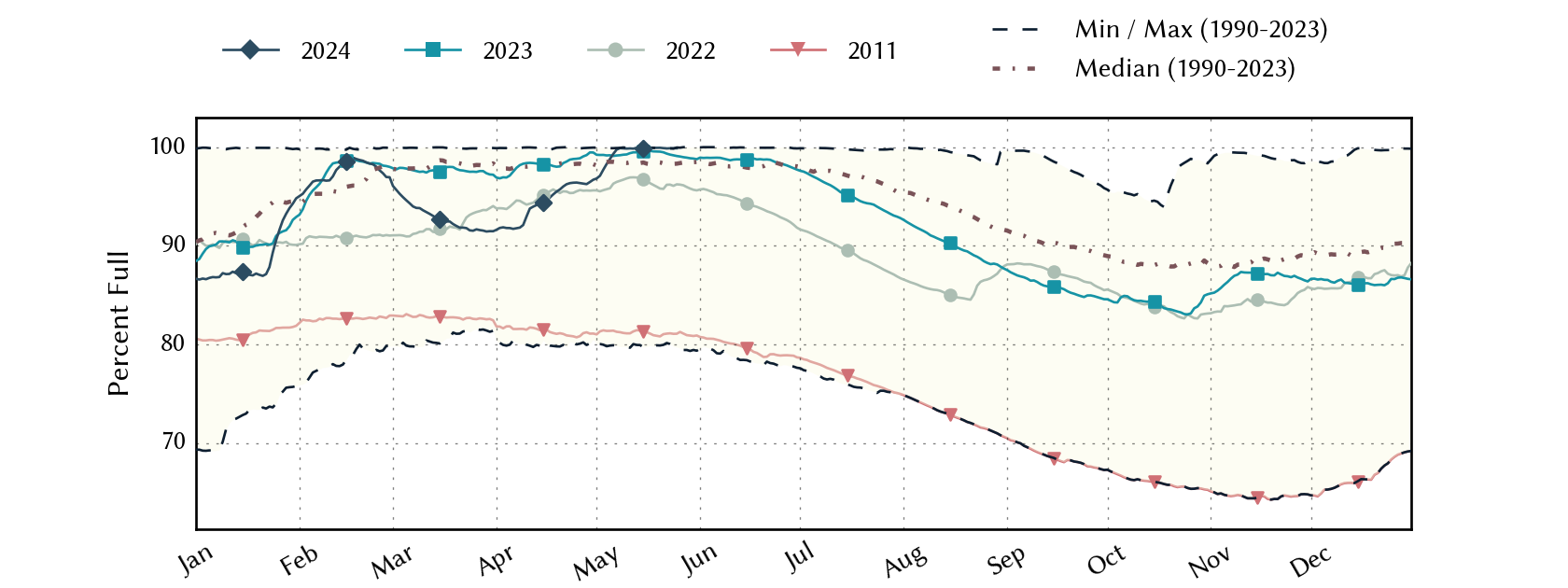
East-Texas Climate Division Reservoirs: Monitored Water Supply Reservoirs are 96.9% full on 2024-05-02
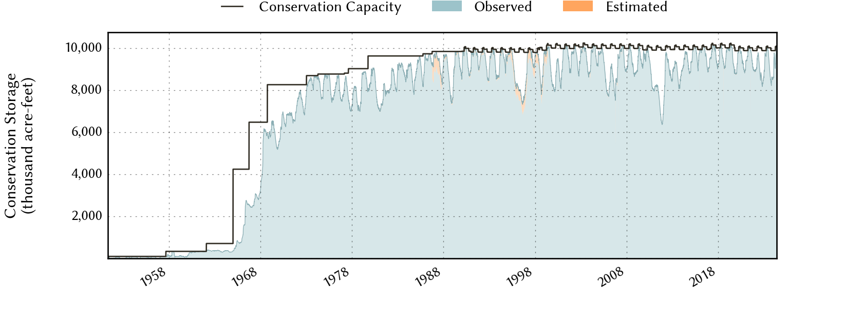
Historical Data
| Date | Percent Full |
Reservoir Storage (acre-ft) |
Conservation Storage (acre-ft) |
Conservation Capacity (acre-ft) |
|
|---|---|---|---|---|---|
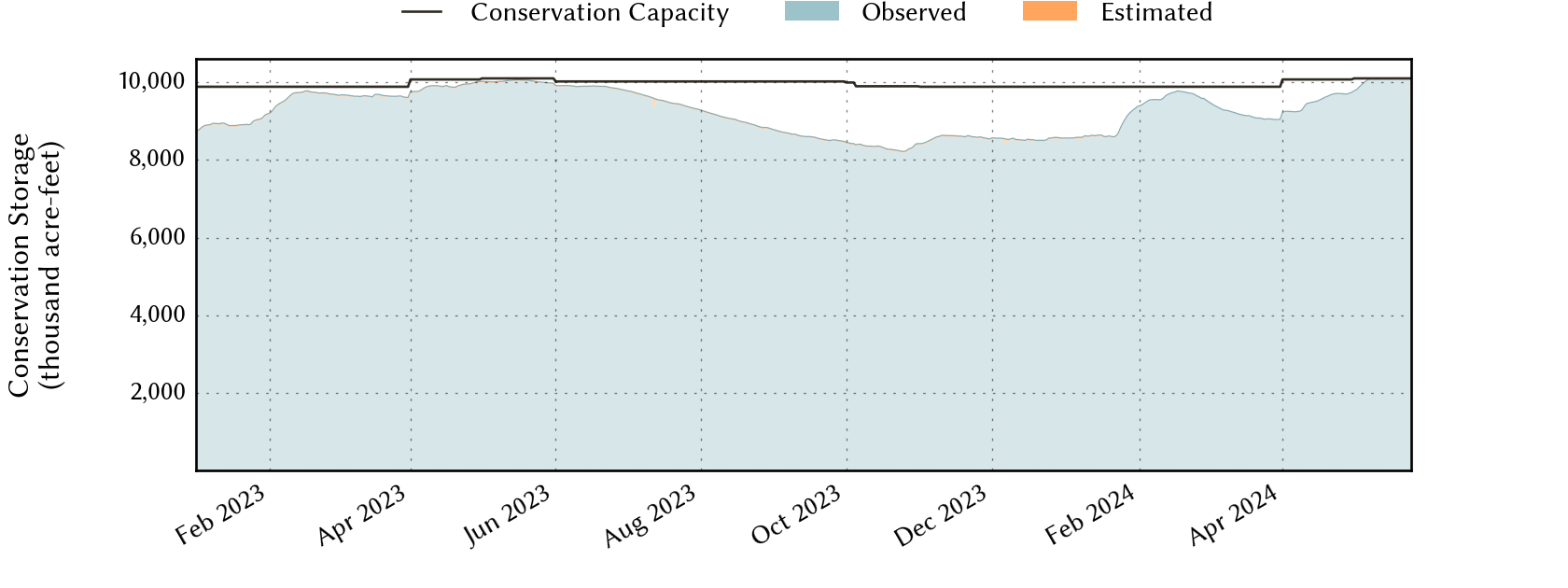
| Today | 2024-05-02 | 96.9 | 12,755,172 | 9,784,426 | 10,101,935 |
| Yesterday | 2024-05-01 | 96.8 | 12,757,139 | 9,774,669 | 10,101,935 |
| 2 days ago | 2024-04-30 | 96.6 | 12,830,966 | 9,735,931 | 10,074,732 |
| 1 week ago | 2024-04-25 | 96.4 | 12,480,104 | 9,707,951 | 10,074,732 |
| 1 month ago | 2024-04-02 | 91.7 | 11,930,088 | 9,241,892 | 10,074,732 |
| 3 months ago | 2024-02-02 | 95.3 | 12,133,477 | 9,419,677 | 9,886,943 |
| 6 months ago | 2023-11-02 | 85.2 | 10,614,778 | 8,427,962 | 9,886,943 |
| 1 year ago | 2023-05-02 | 99.2 | 12,590,848 | 10,022,136 | 10,101,935 |
*
Percent Full is based on Conservation Storage and Conservation Capacity and doesn't account for storage in flood pool.
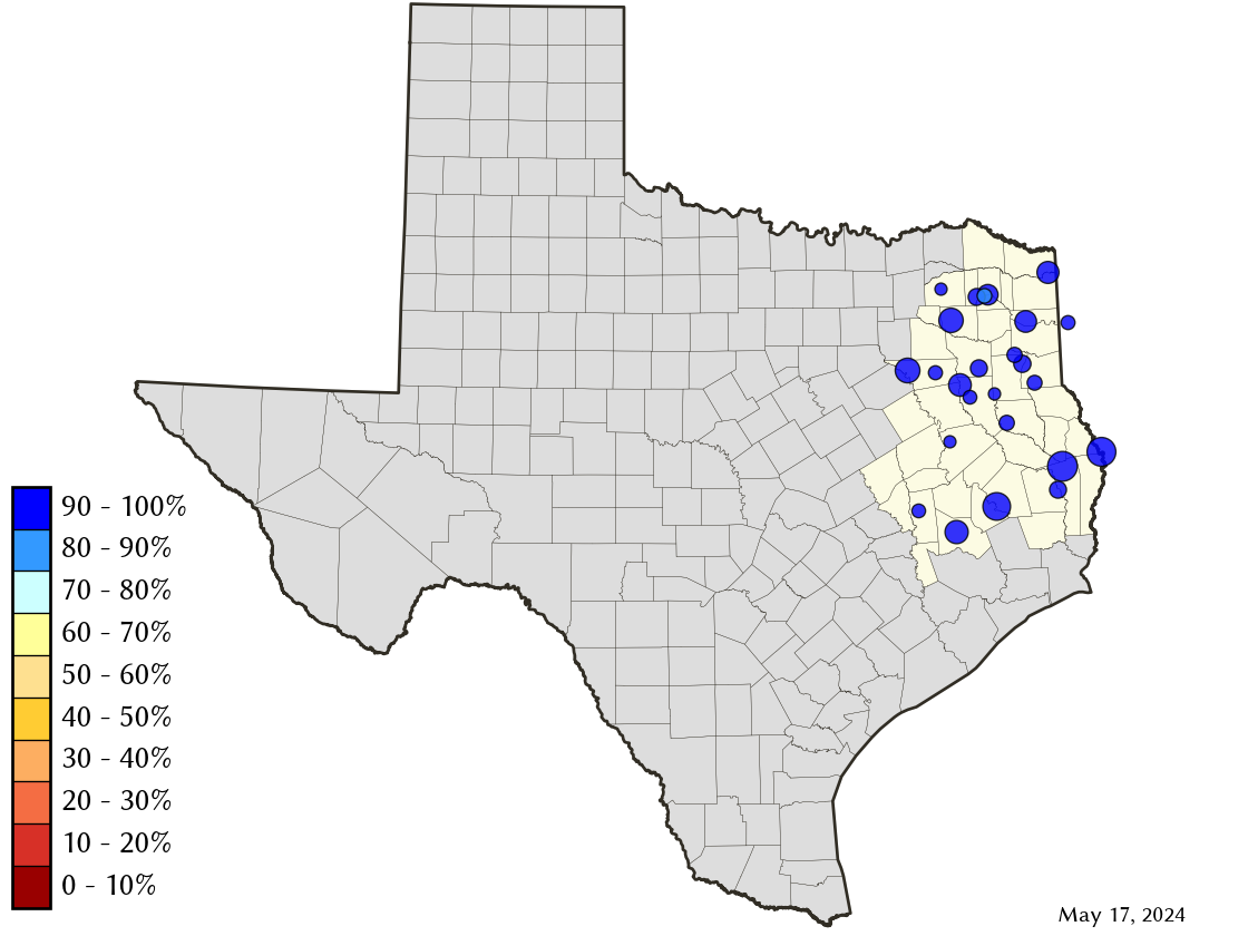
Area Map
Reservoir Storage
| Reservoir | Percent Full |
Water Level (ft) |
Height Above Conservation Pool (ft) |
Reservoir Storage (acre-ft) |
Conservation Storage (acre-ft) |
Conservation Capacity (acre-ft) |
Surface Area (acres) |
|---|---|---|---|---|---|---|---|
| Athens | 100.0 | 440.58 | 0.58 | 30,637 | 29,503 | 29,503 | - n.a. - |
| B A Steinhagen | 75.5 | 81.20 | -1.80 | 52,328 | 52,255 | 69,186 | 8,578 |
| Bob Sandlin | 100.0 | 337.89 | 0.39 | 206,629 | 192,417 | 192,417 | - n.a. - |
| Caddo 1 | 100.0 | 170.28 | 1.78 | 178,122 | 29,898 | 29,898 | 30,649 |
| Cedar Creek | 100.0 | 322.19 | 0.19 | 651,020 | 644,686 | 644,686 | - n.a. - |
| Cherokee | 100.0 | 280.48 | 0.48 | 46,747 | 40,094 | 40,094 | - n.a. - |
| Conroe | 100.0 | 201.82 | 0.82 | 435,090 | 417,577 | 417,577 | 20,931 |
| Cypress Springs | 100.0 | 379.89 | 1.89 | 72,998 | 66,756 | 66,756 | - n.a. - |
| Fork | 100.0 | 403.21 | 0.21 | 642,090 | 605,061 | 605,061 | - n.a. - |
| Gibbons Creek | 94.9 | 246.48 | -0.52 | 26,112 | 24,408 | 25,721 | 2,496 |
| Houston County | 100.0 | 260.57 | 0.57 | 18,409 | 17,113 | 17,113 | - n.a. - |
| Jacksonville | 100.0 | 422.28 | 0.28 | 26,058 | 25,670 | 25,670 | - n.a. - |
| Lake O' the Pines | 100.0 | 235.93 | 5.93 | 390,870 | 268,566 | 268,566 | - n.a. - |
| Livingston | 100.0 | 132.27 | 1.27 | 1,706,377 | 1,603,504 | 1,603,504 | - n.a. - |
| Martin | 100.0 | 306.14 | 0.14 | 76,422 | 75,726 | 75,726 | - n.a. - |
| Monticello | 87.3 | 337.73 | -2.27 | 30,338 | 30,338 | 34,740 | 1,796 |
| Murvaul | 100.0 | 266.12 | 0.82 | 41,139 | 38,285 | 38,285 | - n.a. - |
| Nacogdoches | 100.0 | 279.16 | 0.16 | 39,874 | 39,522 | 39,522 | - n.a. - |
| Palestine | 100.0 | 345.66 | 0.66 | 382,762 | 367,303 | 367,303 | - n.a. - |
| Sam Rayburn | 89.7 | 161.71 | -2.69 | 2,581,657 | 2,562,701 | 2,857,077 | 105,508 |
| Striker | 97.1 | 292.75 | -0.25 | 21,313 | 16,391 | 16,878 | 1,935 |
| Sulphur Springs | 100.0 | 459.59 | 0.64 | 19,014 | 17,747 | 17,747 | - n.a. - |
| Toledo Bend 2 | 100.0 | 172.45 | 0.45 | 4,571,449 | 2,236,450 | 2,236,450 | 184,651 |
| Tyler | 100.0 | 375.72 | 0.34 | 78,902 | 72,073 | 72,073 | - n.a. - |
| Wright Patman | 100.0 | 230.69 | 3.19 | 428,815 | 310,382 | 310,382 | - n.a. - |
footnotes
1
Caddo Lake straddles the border of Texas and Louisiana, Texas has rights to 50% of Lake Caddo's total conservation capacity. Percent full, conservation storage and conservation capacity are based on the Texas share.
2
Toledo Bend Reservoir straddles the border of Texas and Louisiana, Texas has rights to 50% of Toledo Bend Reservoir's total conservation capacity. Percent full, conservation storage and conservation capacity are based on the Texas share.