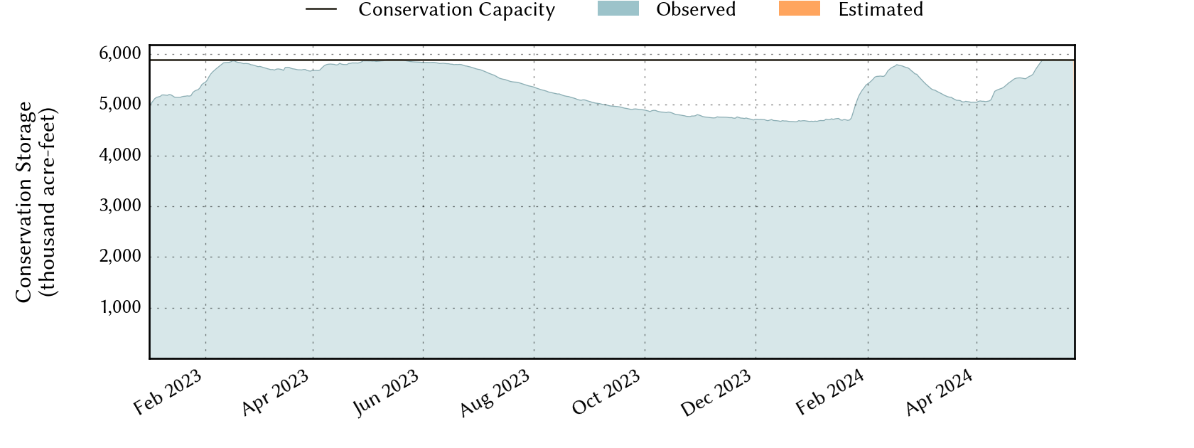
East-Texas Planning Region Reservoirs: Monitored Water Supply Reservoirs are 94.7% full on 2024-05-02
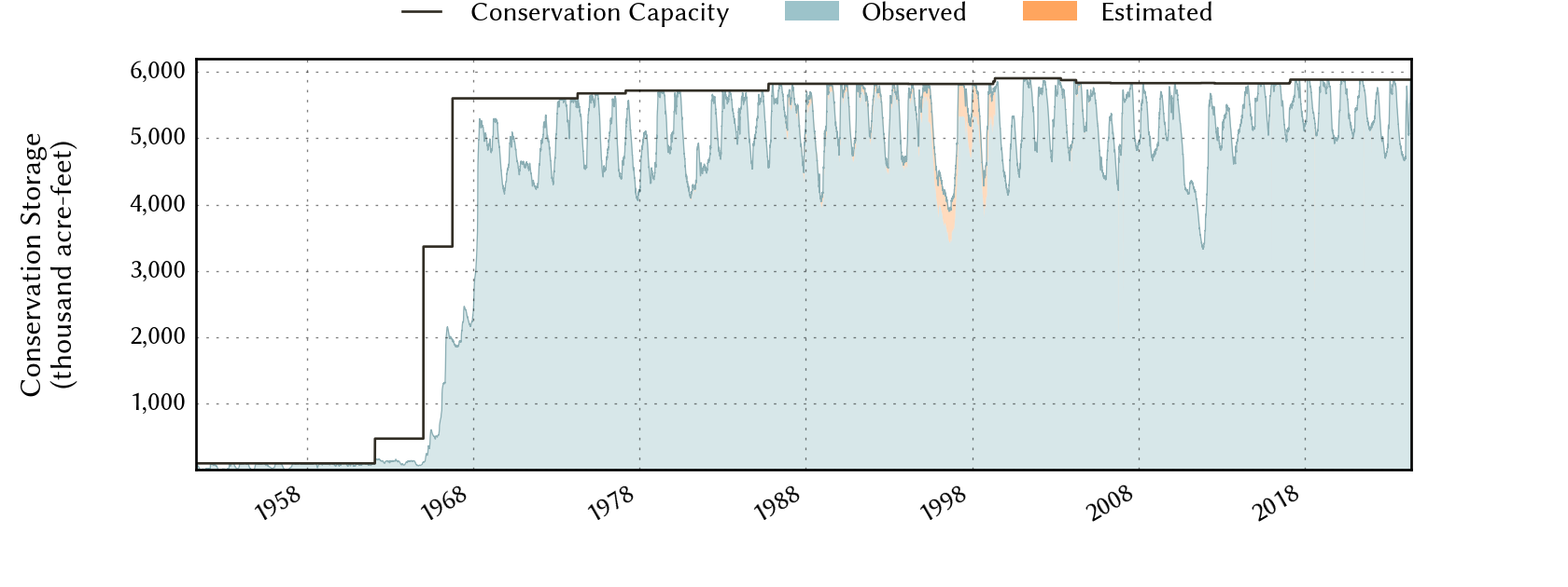
Historical Data
| Date | Percent Full |
Reservoir Storage (acre-ft) |
Conservation Storage (acre-ft) |
Conservation Capacity (acre-ft) |
|
|---|---|---|---|---|---|
| Today | 2024-05-02 | 94.7 | 7,967,697 | 5,573,086 | 5,884,880 |
| Yesterday | 2024-05-01 | 94.5 | 7,957,478 | 5,563,852 | 5,884,880 |
| 2 days ago | 2024-04-30 | 94.3 | 7,943,942 | 5,550,223 | 5,884,880 |
| 1 week ago | 2024-04-25 | 93.8 | 7,858,908 | 5,522,754 | 5,884,880 |
| 1 month ago | 2024-04-02 | 86.0 | 7,206,733 | 5,058,237 | 5,884,880 |
| 3 months ago | 2024-02-02 | 92.4 | 7,637,003 | 5,436,500 | 5,884,880 |
| 6 months ago | 2023-11-02 | 81.0 | 6,679,110 | 4,766,141 | 5,884,880 |
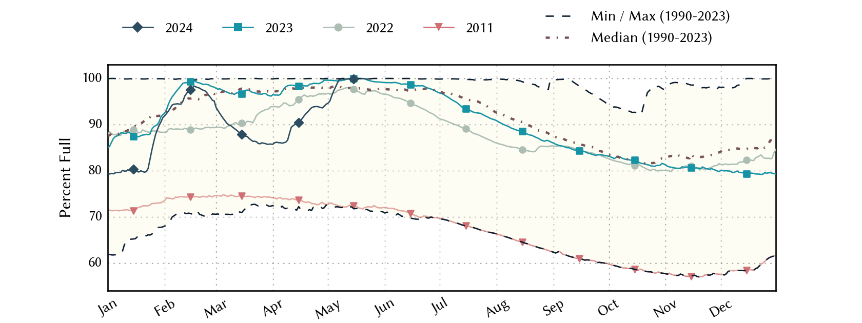
| 1 year ago | 2023-05-02 | 99.6 | 8,166,449 | 5,860,812 | 5,884,880 |
*
Percent Full is based on Conservation Storage and Conservation Capacity and doesn't account for storage in flood pool.
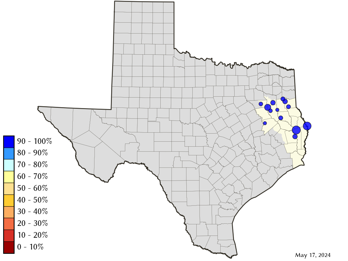
Area Map
Reservoir Storage
| Reservoir | Percent Full |
Water Level (ft) |
Height Above Conservation Pool (ft) |
Reservoir Storage (acre-ft) |
Conservation Storage (acre-ft) |
Conservation Capacity (acre-ft) |
Surface Area (acres) |
|---|---|---|---|---|---|---|---|
| Athens | 100.0 | 440.58 | 0.58 | 30,637 | 29,503 | 29,503 | - n.a. - |
| B A Steinhagen | 75.5 | 81.20 | -1.80 | 52,328 | 52,255 | 69,186 | 8,578 |
| Cherokee | 100.0 | 280.48 | 0.48 | 46,747 | 40,094 | 40,094 | - n.a. - |
| Houston County | 100.0 | 260.57 | 0.57 | 18,409 | 17,113 | 17,113 | - n.a. - |
| Jacksonville | 100.0 | 422.28 | 0.28 | 26,058 | 25,670 | 25,670 | - n.a. - |
| Martin | 100.0 | 306.14 | 0.14 | 76,422 | 75,726 | 75,726 | - n.a. - |
| Murvaul | 100.0 | 266.12 | 0.82 | 41,139 | 38,285 | 38,285 | - n.a. - |
| Nacogdoches | 100.0 | 279.16 | 0.16 | 39,874 | 39,522 | 39,522 | - n.a. - |
| Palestine | 100.0 | 345.66 | 0.66 | 382,762 | 367,303 | 367,303 | - n.a. - |
| Sam Rayburn | 89.7 | 161.71 | -2.69 | 2,581,657 | 2,562,701 | 2,857,077 | 105,508 |
| Striker | 97.1 | 292.75 | -0.25 | 21,313 | 16,391 | 16,878 | 1,935 |
| Toledo Bend 1 | 100.0 | 172.45 | 0.45 | 4,571,449 | 2,236,450 | 2,236,450 | 184,651 |
| Tyler | 100.0 | 375.72 | 0.34 | 78,902 | 72,073 | 72,073 | - n.a. - |
footnotes
1
Toledo Bend Reservoir straddles the border of Texas and Louisiana, Texas has rights to 50% of Toledo Bend Reservoir's total conservation capacity. Percent full, conservation storage and conservation capacity are based on the Texas share.