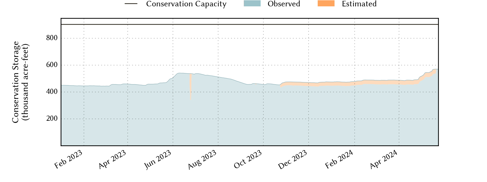
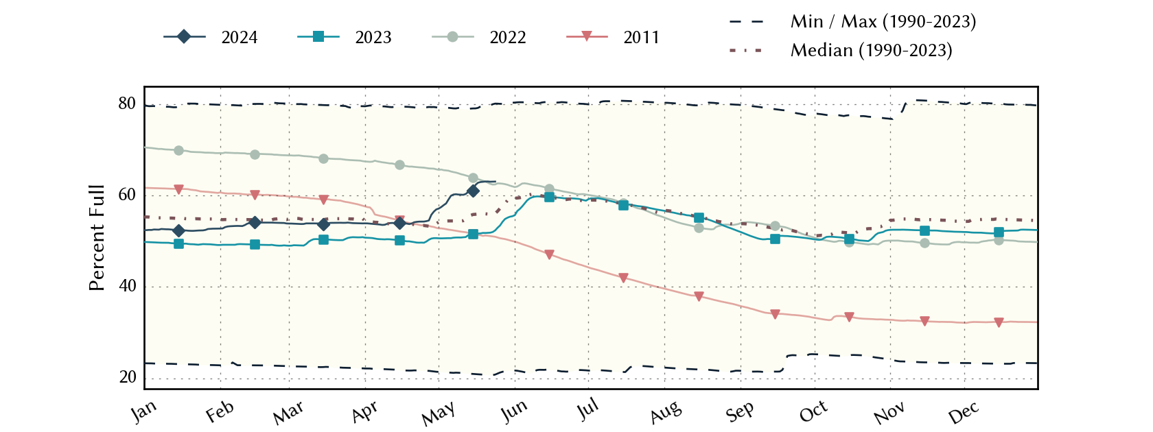
Low-Rolling-Plains Climate Division Reservoirs: Monitored Water Supply Reservoirs are 56.1% full on 2024-05-01
Historical Data
| Date | Percent Full |
Reservoir Storage (acre-ft) |
Conservation Storage (acre-ft) |
Conservation Capacity (acre-ft) |
|
|---|---|---|---|---|---|
| Most recent | 2024-05-01 | 56.1 | 509,848 | 507,304 | 903,870 |
| 1 day prior | 2024-04-30 | 55.9 | 508,225 | 505,681 | 903,870 |
| 2 days prior | 2024-04-29 | 55.5 | 503,856 | 501,312 | 903,870 |
| 1 week prior | 2024-04-24 | 53.4 | 485,148 | 482,604 | 903,870 |
| 1 month prior | 2024-04-01 | 53.3 | 484,710 | 482,166 | 903,870 |
| 3 months prior | 2024-02-01 | 52.5 | 477,029 | 474,485 | 903,870 |
| 6 months prior | 2023-11-01 | 52.4 | 476,433 | 473,889 | 903,870 |
| 1 year prior | 2023-05-01 | 50.6 | 460,203 | 457,659 | 903,870 |
*
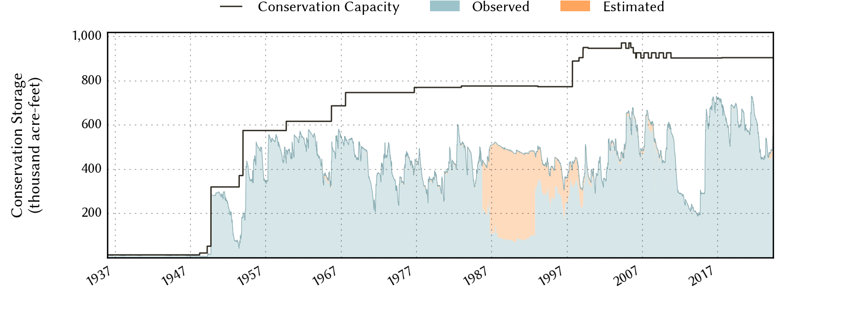
Percent Full is based on Conservation Storage and Conservation Capacity and doesn't account for storage in flood pool.
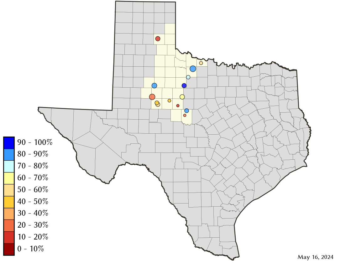
Area Map
Reservoir Storage
| Reservoir | Percent Full |
Water Level (ft) |
Height Above Conservation Pool (ft) |
Reservoir Storage (acre-ft) |
Conservation Storage (acre-ft) |
Conservation Capacity (acre-ft) |
Surface Area (acres) |
|---|---|---|---|---|---|---|---|
| Abilene | 11.4 | 1,993.53 | -18.77 | 902 | 902 | 7,900 | 165 |
| Alan Henry | 86.7 | 2,215.13 | -4.87 | 83,408 | 83,408 | 96,207 | 2,456 |
| Champion Creek | 57.1 | 2,068.85 | -14.15 | 23,758 | 23,758 | 41,580 | 1,030 |
| Coleman | 59.6 | 1,707.98 | -9.52 | 22,715 | 22,697 | 38,075 | 1,368 |
| Colorado City | 47.2 | 2,057.03 | -13.17 | 14,504 | 14,504 | 30,758 | - n.a. - |
| Fort Phantom Hill | 67.5 | 1,629.24 | -6.66 | 47,258 | 47,252 | 70,030 | 2,993 |
| Greenbelt | 11.2 | 2,617.96 | -46.04 | 7,174 | 6,742 | 59,968 | 463 |
| Hords Creek | 21.3 | 1,879.11 | -20.89 | 1,729 | 1,726 | 8,109 | 165 |
| J B Thomas | 19.3 | 2,225.61 | -32.39 | 39,253 | 38,580 | 199,931 | 3,050 |
| Kemp | 80.8 | 1,141.24 | -2.76 | 198,338 | 198,212 | 245,307 | 11,031 |
| Millers Creek | 57.8 | 1,327.64 | -6.36 | 16,767 | 15,484 | 26,768 | 1,385 |
| North Fork Buffalo Creek | 38.9 | 1,040.43 | -7.57 | 5,986 | 5,986 | 15,400 | 800 |
| Stamford | 82.4 | 1,415.14 | -1.66 | 42,479 | 42,476 | 51,570 | 4,452 |
| Sweetwater | 45.5 | 2,103.14 | -13.36 | 5,577 | 5,577 | 12,267 | 372 |