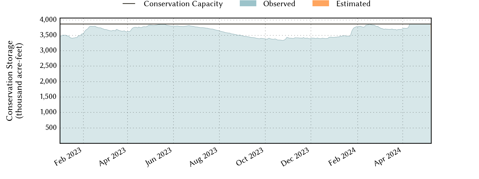
Sabine River Basin Reservoirs: Monitored Water Supply Reservoirs are 100.0% full on 2024-04-27
Historical Data
| Date | Percent Full |
Reservoir Storage (acre-ft) |
Conservation Storage (acre-ft) |
Conservation Capacity (acre-ft) |
|
|---|---|---|---|---|---|
| Today | 2024-04-27 | 100.0 | 6,199,647 | 3,866,743 | 3,867,301 |
| Yesterday | 2024-04-26 | 100.0 | 6,199,647 | 3,866,743 | 3,867,301 |
| 2 days ago | 2024-04-25 | 100.0 | 6,230,318 | 3,867,301 | 3,867,301 |
| 1 week ago | 2024-04-20 | 100.0 | 6,285,499 | 3,867,301 | 3,867,301 |
| 1 month ago | 2024-03-27 | 95.3 | 5,863,488 | 3,686,987 | 3,867,301 |
| 3 months ago | 2024-01-27 | 96.5 | 5,920,026 | 3,731,681 | 3,867,301 |
| 6 months ago | 2023-10-27 | 86.6 | 5,272,866 | 3,350,990 | 3,867,301 |
| 1 year ago | 2023-04-27 | 97.9 | 6,026,958 | 3,786,466 | 3,867,301 |
*
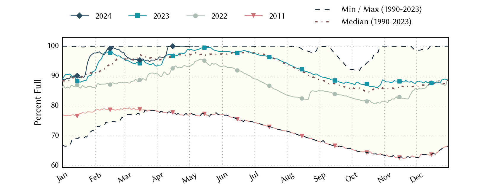
Percent Full is based on Conservation Storage and Conservation Capacity and doesn't account for storage in flood pool.
Area Map
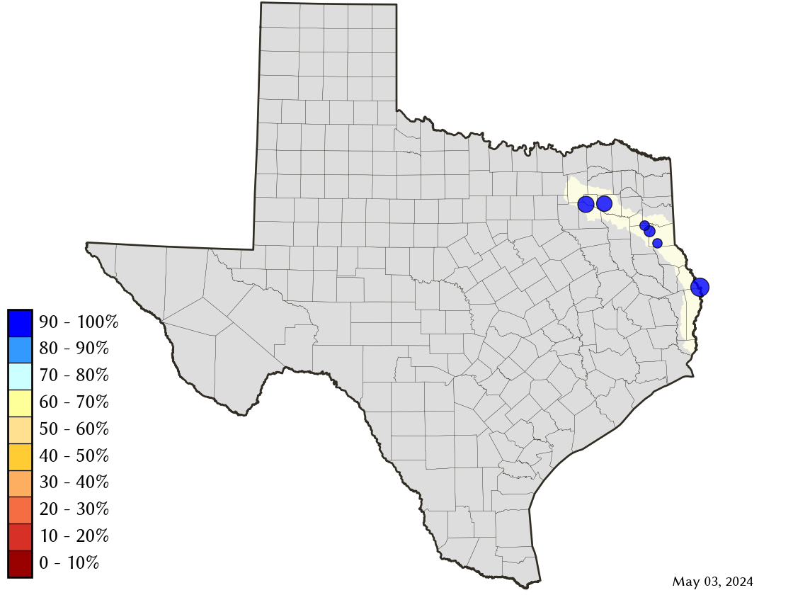
Reservoir Storage
| Reservoir | Percent Full |
Water Level (ft) |
Height Above Conservation Pool (ft) |
Reservoir Storage (acre-ft) |
Conservation Storage (acre-ft) |
Conservation Capacity (acre-ft) |
Surface Area (acres) |
|---|---|---|---|---|---|---|---|
| Cherokee | 100.0 | 280.39 | 0.39 | 46,387 | 40,094 | 40,094 | - n.a. - |
| Fork | 100.0 | 403.34 | 0.34 | 645,574 | 605,061 | 605,061 | - n.a. - |
| Martin | 100.0 | 306.13 | 0.13 | 76,372 | 75,726 | 75,726 | - n.a. - |
| Murvaul | 100.0 | 265.50 | 0.20 | 38,973 | 38,285 | 38,285 | - n.a. - |
| Tawakoni | 100.0 | 438.69 | 1.19 | 916,458 | 871,685 | 871,685 | - n.a. - |
| Toledo Bend 1 | 100.0 | 171.95 | -0.05 | 4,475,883 | 2,235,892 | 2,236,450 | 182,250 |
footnotes
1
Toledo Bend Reservoir straddles the border of Texas and Louisiana, Texas has rights to 50% of Toledo Bend Reservoir's total conservation capacity. Percent full, conservation storage and conservation capacity are based on the Texas share.