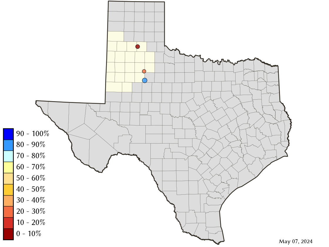
Llano-Estacado Planning Region Reservoirs: Monitored Water Supply Reservoirs are 49.7% full on 2026-07-28
Historical Data
| Date | Percent Full |
Reservoir Storage (acre-ft) |
Conservation Storage (acre-ft) |
Conservation Capacity (acre-ft) |
|
|---|---|---|---|---|---|
| Today | 2026-07-28 | 49.7 | 86,761 | 86,761 | 174,503 |
| Yesterday | 2026-07-27 | 49.8 | 86,871 | 86,871 | 174,503 |
| 2 days ago | 2026-07-26 | 49.9 | 87,017 | 87,017 | 174,503 |
| 1 week ago | 2026-07-21 | 50.2 | 87,640 | 87,640 | 174,503 |
| 1 month ago | 2026-06-28 | 51.0 | 88,926 | 88,926 | 174,503 |
| 3 months ago | 2026-04-28 | 52.9 | 92,268 | 92,268 | 174,503 |
| 6 months ago | 2026-01-28 | 55.8 | 97,317 | 97,317 | 174,503 |
| 1 year ago | 2025-07-28 | 63.5 | 110,875 | 110,875 | 174,503 |
*
Percent Full is based on Conservation Storage and Conservation Capacity and doesn't account for storage in flood pool.
Area Map
Reservoir Storage
| Reservoir | Type | Percent Full |
Water Level (ft) |
Height Above Conservation Pool (ft) |
Reservoir Storage (acre-ft) |
Conservation Storage (acre-ft) |
Conservation Capacity (acre-ft) |
Surface Area (acres) |
|---|---|---|---|---|---|---|---|---|
| Alan Henry |

|
76.4 | 2,210.89 | -9.11 | 73,493 | 73,493 | 96,207 | 2,231 |
| Mackenzie |
|
11.6 | 3,019.94 | -80.06 | 5,382 | 5,382 | 46,450 | 244 |
| White River |
|
24.8 | 2,350.70 | -21.50 | 7,886 | 7,886 | 31,846 | 709 |